Energy is imparted to the ocean by the wind, temperature differences between the ocean and the atmosphere, pressure forces due the horizontal differences in the density of ocean water, and finally by the rotation of the earth itself.
The cascade of energy from large scales that we can see (weather systems, large ocean circulation) to small scales experience by plankton or, even smaller yet, to the viscous forces experienced by dissolved organic molecules binding to water molecules themselves, is of such interest to scientists , that there is even a poem written about it:
Big whorls have little whorls
Which feed on their velocity,
And little whorls have lesser
whorls And so on to viscosity.
Lewis Fry Richardson, 1922
Oceanic circulation in baffin Bay
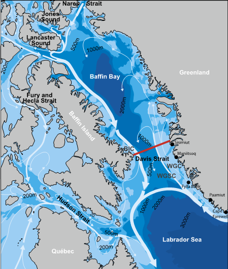
In Baffin Bay, the biggest whorl is confined and steered by the basin itself, some 500 km wide by 1200 km long, mixing waters of several origins. The West Greenland Current (WGC) hugs the coast, carrying cold Artic water, having made a 5000 km journey from the Arctic, around the east coast of Greenland, and then into Baffin Bay. It is accompanied by a deeper and more influential warmer salty North Atlantic water in the West Greenland Shelf Current (WGSC). Along the west side of Baffin, the Baffin Island Current (BIC) is a western boundary current that also brings cold Arctic water to Baffin Bay, via Jones Sound, Lancaster Sound and Nares Strait.
At basin scale, Baffin Bay acts as a slowly stirred mixing bowl, transforming these waters of various origins. First, the physical nature of the bowl confines the currents. Simply put, Baffin Bay is a bit like a deep bathtub with steep sides with a bottom depth of over 2000 m. You can set your drink down on the wide shelf just 300 m deep on the right (east). Water moves quickly to the south along the much narrower shelf on the left (west). There are shallow sills (300 – 600 m deep) in the north (Nares Strait) and south (Davis Strait) that help retain Baffin Bay’s deep water for a long time. That warm WGSC is the Jacuzzi jet coming in under your right arm as you lean back against the sill at Davis Strait and cool your toes in the Arctic water entering from the north.
Let the force be with you!

The circulation in Baffin Bay is counter-clockwise for several reasons. First, there is a gravitational force setup by a sea level difference between the light, fluffy, cold and fresher Arctic Ocean and the warmer, saltier, and denser Labrador Sea, creating a constant push from north to south. This helps send the cold Arctic water into Baffin Bay through the Canadian Archipelago. Second, there is a variable density difference between the cold, fresh water entering from the Arctic (H) and the denser, slowly mixing Baffin Bay water (L), setting up a pressure difference (red arrow). The force generated by this pressure difference is balanced by the Coriolis force generated because the earth is rotating, analogous to the force you feel in a car when going around a curve, and you get shoved against the door. The water flows down the pressure gradient and is pushed to the right. This balance of forces causes Baffin Bay water to rotate counter-clockwise. (A similar setup in the Southern Hemisphere would cause water to rotate the other way, or clockwise.)
“Big whorls have little whorls…”
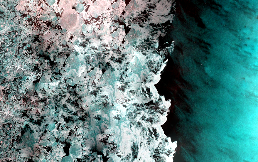
What about the smaller whorls that spin off from the larger whorls? We can see some of the smaller whorls in the wind-driven jets of ice fragments in the marginal ice zone spinning off into open water. Sentinel-1 radar satellite images (like the one shown at the top of this blog post) can “see” the surface of the ice, even through clouds. Relatively flat ice is blue-green. The larger ice that changes the polarization of the light (much like the reflected light from ocean waves that is eliminated when you wear polarized sunglasses) is shown as reddish-white spots.
It turns out these smaller whorls are the result of a local pressure gradient due to smaller scale differences in density, again balanced by the Coriolis force of the earth’s rotation. Working through the math, these eddies can theoretically have a scale as small as 3 -5 km across. But do they really exist at more than the ice edge?
Want to discover the iSPV buoy?
